


City Leaders take Deep Dive into Vision for Transforming Waterfront into a Regional Destination
Joint meeting of City Council and city commissions explores how to bring "generational project" to reality in coming decades

This report from freelance writer Tom Lochner is made possible by the financial support of paid subscribers and other donors to the newsletter.
By Tom Lochner
A renaissance of the Martinez Waterfront, and how to make it happen, were the subject of last Wednesday's joint meeting of the City Council, Planning Commission and Parks, Recreation, Marina and Cultural Commission (PRMCC).
It was the latest step in what a consultant characterized as "a generational project" – one that might take about 30 years to complete – as well as a costly one, estimated at more than $100 million. It met with enthusiasm from a majority of the officials and members of the public in attendance, as a boon for the city's tide- and climate change-battered waterfront and its vast but largely unrealized economic potential.
The current process began last July when the City Council hired SWA Group to prepare the first phase of the Waterfront Marina Trust Land Plan.
The area commonly defined as the Martinez Waterfront is bounded on the west by North Court Street and the Radke Martinez Regional Shoreline, and on the south and southeast by Joe DiMaggio Drive and the Union Pacific railroad right-of-way that also carries Amtrak trains. The south and southwest section contains Waterfront Park.
The Martinez Waterfront extends to the north across the shore of the Carquinez Strait, looping in the fishing pier and the Marina, and also includes tidelands on the northeast side. The east side borders the Martinez Refining Co. grounds.
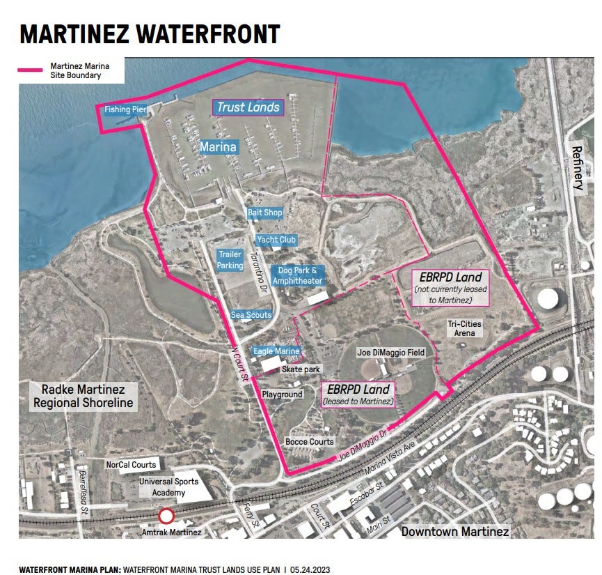
The tidelands, submerged lands and navigable waters are so-called Public Trust lands. They must be managed in accordance with the Public Trust Doctrine, which limits their use to regional and water-dependent or related uses. Those uses moreover must serve a public purpose.
The Waterfront Marina Vision hammered out in earlier meetings projects the Marina as "a recreational asset for the city of Martinez and a regional destination for Contra Costa County and the East Bay."
Wednesday's meeting was designed to get feedback from the council, commissions and the public in preparation for the next steps that need to be taken before the plan can be approved, tentatively projected to happen during the last quarter of 2023.
Daniel Dobson of SWA led off with a description of challenges the marina faces from flooding, with sea levels expected to rise by up to almost 2 feet by 2070. Josh Burnam of Anchor QEA followed with a description of dredging needs, noting that more than 37,000 cubic feet of sediment were removed in the fall, an effort that would need to be substantially supplemented to restore use of the entire basin.
"The marina at large remains essentially choked by sediment," Burnam said.
Among the highest priorities is to fix the battered breakwaters, especially the eastern wall, which is almost completely underwater at high tide. The rest of the marina is also in a high state of deterioration and should be replaced, Burnam said, noting that repairs would be impractical and uneconomical because of code compliance issues. Replacement of the eastern wall would be followed by more dredging, demolition and replacement of several docks if not the entire marina, and possible reconfiguration of the entrance channel.
A member of the public later commented that the breakwater is being torn up by passing ship traffic. Deep-water vessels traveling between the Bay and the ports of Stockton and Sacramento pass through the Carquinez Strait.
On the economic side, Connie Chung of HR&A Advisors noted that Martinez has had little household or employment growth in recent decades. The city's real estate market, meanwhile, is stagnant compared with the surrounding region, she said.
However, with appropriate investment, existing city assets can spur economic development, Chung said. Key ingredients would be investments in marina infrastructure, "connectivity improvements" linking the waterfront to the downtown, and downtown housing and employment growth.
The Preferred Plan builds on six themes hashed out during several months of community outreach: promoting waterfront dining options; more and varied waterfront recreation; better public access to the waterfront; a waterfront that is "connected and contextual;" potential ferry or water taxi service; and addressing the future impacts of sea level rise.
More specifically, it calls for an "Activated Marina Promenade" connected to Downtown Martinez and the trail network, with enhanced recreation opportunities at Waterfront Park, and restored tideland.
The Preferred Plan, in its "interim condition," envisions completion of fishing pier improvements; revitalization of the Marina; construction of a Marina Village; a partnership for an educational and events center; an improved dog agility park; completion of a crossing at Court Street and other road improvements; a community stage; and an expanded skate park. At full buildout, it also envisions a ferry terminal; a shuttle to downtown and the Amtrak station; expanded dry storage; and tidal restoration.
The plan divides the Martinez Waterfront into three “character zones”: Marina Promenade, Waterfront Park and Tidelands.
Full build-out could take 30 years, give or take depending on momentum, while the majority of investment could be done in the first 10 years, according to Chung, who added, "This is a generational project."
The project would require a total investment of $103.8 million to $120.3 million, according to Chung. Of that, $30.4 million to $35.6 million would go to marina improvements; $62 million to $70 million toward the Marina Promenade with its dining facilities and Educational & Events Center; $3.4 million to $4.5 million for the Waterfront Park, with an expanded skate park, community stage and picnic pavilions; and $8 million to $10.2 million for tidelands restoration and parking expansion at a dry storage area and an improved and expanded dog park.
Funding would need to come from grants and allocations from different levels of government in addition to the city's own resources, as well as some public-private partnering and public financing such as bonds.
Questions, suggestions and issues raised in the ensuing comment session included:
More agencies will likely become involved, including the Bay Conservation and Development Commission (BCDC) and the U.S. Army Corps of Engineers.
Could a changing waterline affect jurisdictions among different agencies?
How much fill is needed for low-lying areas such as parking lots, and will the ground sink further, and how much? (The matter will be referred to a geotechnical expert, officials and consultants agreed.)
Which structures should be kept accessible during high water by raising the ground using fill? Which ones should be built on stilts? The latter is a more economical measure that would protect them from flooding but render them temporarily inaccessible.
How long will improvements last? (Concrete and steel elements should last about 50 years and perhaps as long as 75, Burnam said.)
A planning commissioner raised the issue of emergency egress from the waterfront during train derailments that spill hazardous materials, and other emergencies. A PRMCC commissioner called attention to the one-way-in, one-way-out character of the waterfront, which is currently accessed mostly via Ferry Street. Others noted that even in non-emergencies, stalled trains present a problem. Several commenters welcomed the idea of an elevated crossing for vehicles and pedestrians at Court Street.
Should live-aboards at the marina be encouraged?
Should the marina be reduced to a smaller size? (an idea that generated little enthusiasm). Or should it be expanded to include more slips? (an idea greeted with more enthusiasm).
Recommendations to reach out to Native American groups for participation
Automated people movers to increase accessibility
Roundabouts for traffic safety
More reliance on solar power
More accommodations and routes for bicycles
Greater promotion of Martinez's music scene as an attraction; one commenter told of five live bands performing on Mother's Day weekend.
There was some confusion about a "requirement to transmit 20 percent of annual gross revenues generated from the Trust Lands to the State Lands Commission," as the consultants' presentation phrased it – whether that refers to 20 percent of a concessionaire's gross revenues (one concessionaire being Almar, which runs the marina), or 20 percent of the city's share. City Manager Michael Chandler clarified that 20 percent of what the city gets will be remitted to State Lands.
The next steps in the process are:
Preparation of the Trust Land Use Plan (TLUP) document, which will be submitted to the City Council for direction to formally coordinate with the State Lands Commission: tentatively projected for July.
Coordination and quest for approval of the TLUP with the State Lands Commission: tentatively projected for October.
City Council adoption of the Final TLUP: tentatively projected for the period October-December
The consultants' May 24 PowerPoint presentation, replete with maps, photos, graphics and other illustrations, is available at https://legistarweb-production.s3.amazonaws.com/uploads/attachment/pdf/1953054/20230510_Martinez_Waterfront_Joint_Study_Session_Presentation.pdf
Council to tackle flag policy, budget at Wednesday meeting
The City Council will tackle two items at a special meeting tonight (May 31), starting at 7 p.m. at City Hall:
Adopting a policy for the display of flags at Ignacio Plaza, clarifying that the “city shall not display a ceremonial flag based solely on a request from a third party, but rather, the request must come from a member of the City Council or the city manager” while meeting other provisions of the policy, which can be found at this link: https://legistarweb-production.s3.amazonaws.com/uploads/attachment/pdf/1977125/Attachment_A_-_Flag_Display_Policy.pdf
A fiscal year 2023-25 budget workshop. As the accompanying staff report details, the city is facing “mounting financial constraints” driven by increased labor and benefits costs, rising insurance premiums and “tepid overall revenue growth.” The staff report also addresses a reorganization and restructuring of City Hall staff to “better align with best practice models of modern municipal government.” The agenda for Wednesday’s meeting (also accessible via Zoom), including staff reports and other relevant attachments, can be found by clicking this link.
Community and Economic Development director hired
The city has announced the hiring of Jill Bergman to lead its Community and Economic Development Department, effective tomorrow (June 1). She will oversee such functions as planning, building, code enforcement, economic development and sustainability. Read about her background and role in the city newsletter by clicking here.
Grand plans, no money. Slip fees don’t bring in enough to pay for dredging, much less building a new east wall/breakwater ... yet we still keep pursuing plans for a yacht harbor. We need to reimagine the marina ... as a kayak/personal watercraft recreational area. No dredging required and it would be a great regional draw.